CONTENTS
2......... DESIGN OF REGULAR MARINE TRAVEL ROUTES
2.3 Regular Marine Travel Routes
3......... SURVEILLANCE & MONITORING
4......... PRECAUTIONARY MEASURES
APPENDICES
Appendix A Marine
Work Areas under the Contract
Appendix B Distribution
of CWD in Hong Kong
Appendix C Existing
Fairways and Channels
Appendix D Local
Marine Route Constraints & Marine Facilities
Appendix E Photos of Working Vessels
Appendix F Marine Routes and Frequency
between the Works Areas
TABLES
Table 1 General
Information of Working Vessels
Table 2 Information
of Regular Travel Routes
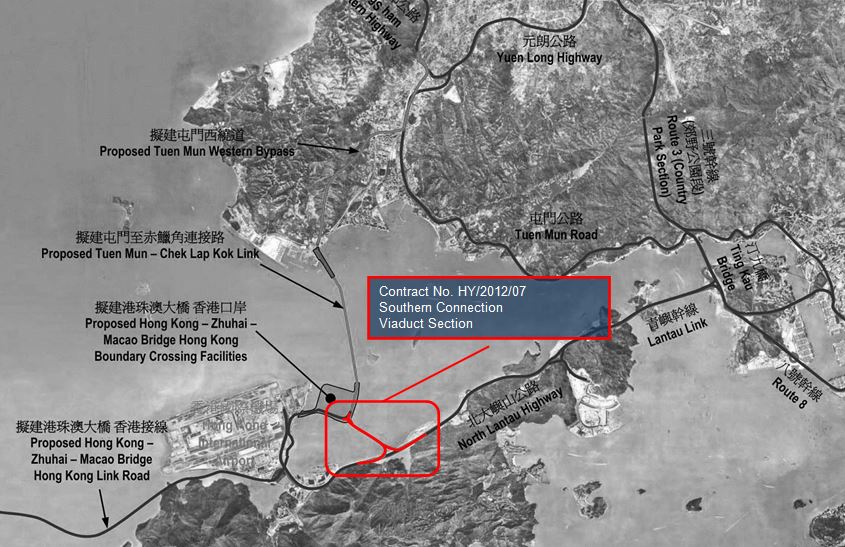
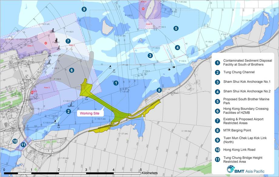
Gammon Construction Limited (GCL) has been
commissioned to design and construct the Contract No. HY/2012/07 �V Tuen Mun Chek
Lap Kok Link �V Southern Connection Viaduct Section
(the Contract) for the Highways Department (HyD) of
the Government of the Hong Kong Special Administrative Region (HKSAR). Layout
of marine work areas under the Contract (the Site/ Works area) is given in Appendix A.
The Works to be
executed comprise the construction of a dual 2-lane elevated carriageway
between the HZMB HKBCF and North Lantau Highway (NLH) with associated slip
roads, as well as modifications and realignment of sections of the NLH and
Cheung Tung Road at North Lantau, and associated works.
This Regular Marine Travel Routes Plan (RMTRP) has been prepared for the works of Contract No.
HY/2012/07 for deposition to the Director of
Environmental Protection in accordance with Condition 2.8 of the Environmental
Permit (EP-354/2009/D) for the Project of Tuen Mun �V Chek Lap Kok Link.
The RMTRP shall describe the
regular marine travel routes of vessel moving to and from the Site/
Works areas to minimize the
chance of vessel collision and the disturbance to the Chinese White Dolphins
(CWD).
There are relevant concerns and constraints as
described in proceeding sections to be considered in mapping out the marine
travel routes.
According to early findings from Agriculture,
Fisheries and Conservation Department (AFCD) of relevancy to the Site/ Works
Area, the CWD occurs mostly to the north and west of Lantau whereas the CWD
uses East and South Lantau seasonally and to a lesser extent. In vicinity of
the Site/ Works area, CWDs are also seen at west of the Brothers' Islands. The regular marine travel routes will be
selected to avoid the above-mentioned dolphin hotspots and to accord the
existing fairways & navigation channels. Appendix B gives the layout of CWD
distribution in Hong Kong.
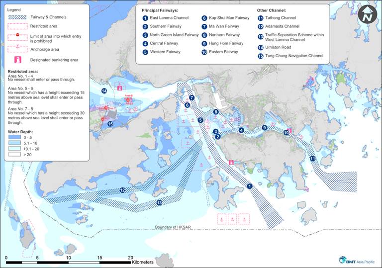
In complying with the safe navigation
requirement in-law, the existing fairways and channels,
including Urmston Road, Tung Chung Navigation Channel, Ma Wan Fairway, Kap Shui Mun Fairway, Traffic
Separation Scheme within the West Lamma Channel, Western
Fairway and East Lamma Channel will be followed and selected as the major marine travel routes.
The Existing Fairway and Channel Plan is shown in Appendix C.
The marine travel route may be locally
adjusted at the judgement of the licensed captain, where necessary in response
to any incident. This is to ensure safe navigation pursuant to relevant safe
navigation requirement and international practice with navigation aids/ support
from marine traffic control team of Marine Department.
Also actual seaworthy conditions such as wind,
current, wave, etc. would pose as ad-hoc constraints whereby the marine travel
route may be adjusted locally.
There are seven restricted waters in the
vicinity of Hong Kong International Airport where working vessels are not
allowed to pass through except with prior authorization. Further the airport
height restriction (AHR) limit will dictate the marine travel routes of working
vessels for delivery of excessively tall precast/ prefabricated units.
The local constraints imposed by the purposed
South Brother Marine Park in vicinity, Sham Shui Kok
Anchorages, contaminated sediment disposal facility at South of Brothers,
adjacent projects and other marine facilities shall also be considered in
designing marine travel routes. The
layout in Appendix
D depicts the local marine route constraints and relevant marine
facilities around the Site/ Works Area.
In line with the works
progress and serving for different purposes, vessels of
various types as listed below will be used during the
construction stage. Photos of vessels
are provided in Appendix
E.
l Crane
barge
l Derrick
lighter
l Flat
top barge
l Tug
boat
l Hopper
barge
l Marine
G.I. Vessel
l Inspection
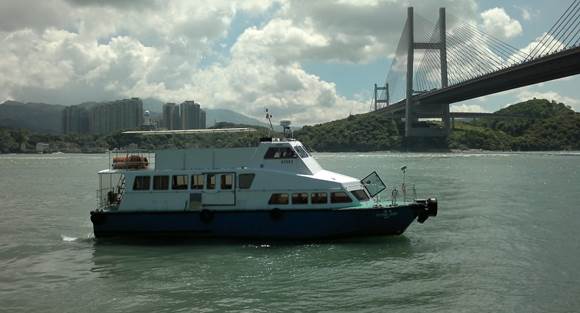
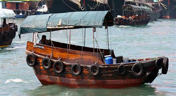
boat (incl. passenger ferry/ sampan)
The working vessels, i.e.
crane barge, derrick lighter, flat top barge, hopper barge and Tug Boat, will
mainly be anchored and staying within the Site/ Works Area between HKBCF
Project and north Lantau Island. During the adverse weather (e.g. Typhoon), the
working vessels will leave the Site/ Works Area and go to Tuen
Mun Typhoon Shelter.
Hopper barges shall be used
for delivering to the marine dumping grounds, namely South of Danggan Liedao, South Cheung Chau
and the confined marine sediment disposal facilities at East Sha Chau & to
South of the Brothers subject to SOR��s instruction or CEDD Marine Fill
Committee��s allocations on marine sediment category respectively.
Wherever practicable subject
to SOR��s approval, GCL will pursue for diverting suitable C&D materials to
the preferred disposal grounds at neighbouring sites of Contracts HY/2010/02
HKBCF Reclamation, HY/2011/03 HZMB Section from Scenic Hill to HKBCF and
HY/2012/08 TMCLKL Subsea Tunnel Section or other alternative receptor contracts
for filling purposes. In this regard, the RMTRP will be updated, certified by
Environmental Team Leader before verified by the Independent Environmental
Checker prior to depositing with the Director of Environmental Protection.
There would be for the
Contract a prefabrication yard in Zhong Shan,
Guangdong from where the precast and prefabricated unit will be delivered to
Hong Kong.
WA23 at Tsing Yi would be
the storage area for precast/ prefabricated units and piling construction materials
which would be routinely delivered to the Site/ Works Area.
Concrete in concrete lorry mixer
will be delivered to the Site/ Works Area with flat top barges set off from the
seafront of Project area of North Lantau.
Flat top barges with drilling rigs on board
(namely marine G.I. vessels) or crane mounted would remain stationary most of
the time for the site investigation work or heavy lifting in vicinity of the
Site/ Works Area.
The inspection boats will be
employed for general usage and workers/ project staff transportation between
boarding jetties along North Lantau coastline, Tung Chung, etc. and the Site/
Works Area on an as-need basis.
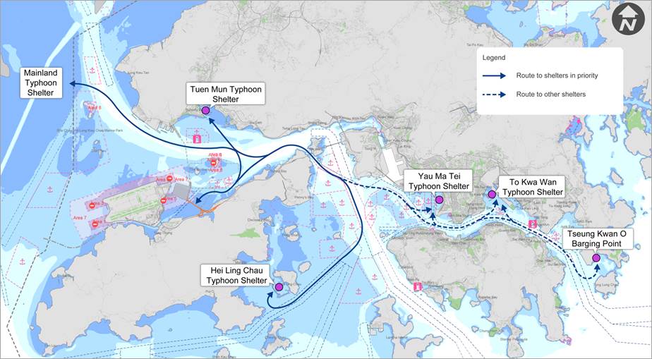
In case of tropical cyclone signal No. 3 to be
hoisted or other design adverse weather conditions, the working vessels will
move or be towed to the nearest available Typhoon Shelter, e.g. Tuen Mun Typhoon Shelter, Yau Ma Tei
Typhoon Shelter or Hei Ling Chau Typhoon Shelter, subject to the occupancy.
The marine routes and
frequency between the works areas are illustrated in Appendix F.
GCL will maintain records of
their usage of
the inspection boats, such as passenger ferry, sampan, etc., Such
records will include, inter alia, details, times and purpose of journeys. The
person using the works boats authorizing the journey will be required to sign
his name and title against the entries. GCL will present current log books for
inspection by the SOR when so required.
The following monitoring measures will be adopted.
1.
Barges such as derrick lighters
or flat top barges for transporting public fill or sediment will be equipped
with Automatic Identification System (AIS) for track logging of vessels.
2.
Hopper barges will be installed
Real Time Tracking & Monitoring of Vessel (RTTMV) System for the purposes
of recording the marine travel route during operation.
3.
For inspection boats, e.g.
passenger ferry and sampan which have the short voyage distance at the North
Lantau coastal area with minimal or nil dolphin sightings, administrative
control will be implemented by a random check to either one of marine travel
routings on monthly basis.
GCL will search to deploy
much suitable working fleets which are equipped with AIS or RTTMV as practicable
as possible.
The daily record of marine
travel route of offsite working fleets, such as barges, derrick lighters, flat top barges and
hopper barges, can be downloaded from the AIS & RTTMV systems, collected
and filed by the marine work supervisor for inspection and monitoring purposes.
Records with graphical presentation/ plots shall
be submitted to SOR, ETL and IEC/ ENPO on a month basis for the purpose of
auditing the compliance with the approved routes. Warning will be served to
the captain and his shipping company or material suppliers if vessel track records
showed the approved marine travel route is not followed.
All vessels used for the
construction of the marine works will comply with all the relevant regulations
and requirements of the Authorities, including:-
(a)
The Shipping and Port Control
Regulations (Cap.313A);
(b)
The Merchant Shipping
(Miscellaneous Craft) Regulations (Cap.313F);
(c)
The Merchant Shipping (Safety)
(Signals of Distress and Prevention of Collisions) Regulations (Cap.369N);
(d)
The Dangerous Goods (Shipping)
Regulations (Cap 295C);
(e)
The Merchant Shipping (Launches
and Ferry Vessels) Regulations (Cap 313E);
(f)
Merchant Shipping (Local
Vessels) Ordinance (Cap.548);
(g)
Shipping and Port Control
(Works) Ordinance (Cap.313X); and
(h)
Marine Parks and Marine
Reserves Regulation (Cap. 476A).
The main issue with the Chinese White Dolphin is a moving vessel
striking and injuring an animal during the period of travel. Information
regarding the locations of frequent sighting near the proposed vessel routes
indicated that the following would also be needed to minimize the chance of a
vessel striking a dolphin.
(a)
When entering into the work areas, all vessels will travel at a speed no
greater than 10 knots.
(b)
Barges for delivering will be selected as large sizes as possible to
reduce the number of delivering trips.
(c)
In an unavoidable circumstance
where the vessel has to travel through the South
Brothers Marine Park, the speed of the vessel would be lowered down to 10 knots
within the Marine Park boundary in accordance with the Marine Parks and Marine
Reserves Regulation (Cap. 476A).
(d)
Should
the captain of vessel observe with naked eyes any dolphin on the line of travelling,
he/she would as practical as possible lower the vessel speed until the dolphin
has left out of his/her sight.
Skipper of all working vessels should be required to use regular travel
routes, in order to minimize the chance of vessel collision. Skippers shall be
briefed by the marine work supervisors of the approved marine travel routes in
the first week of deployment. Refreshment briefings shall be arranged on annual
basis or in the event that the marine travel route is updated along the work
progress.
Skipper of construction vessels working in the North Lantau waters
should undergo training to learn about local dolphins and porpoises. They
should be trained to be aware of the protocol for ��dolphin friendly�� vessel
operation by the marine work supervisor, environmental supervisor and
environmental officer/ engineer of the Contractor in conjunction with the
Environmental Team. Reference will be made to Code of Conduct for Dolphin
Watching Activities available from Agriculture, Fisheries and Conservation
Department.
|
APPENDIX A Marine Work Areas under the Contract
|
|
APPENDIX B Distribution of CWD in Hong
Kong |
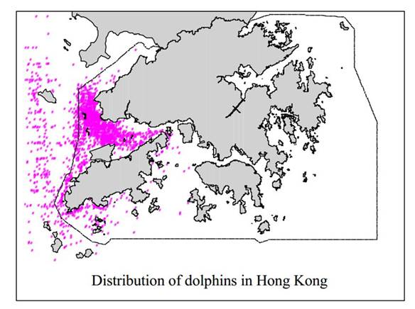
Distribution of Chinese White
Dolphins in Hong Kong
(Source : AFCD 2000, The Conservation Programme for the Chinese White Dolphin in Hong Kong)
|
APPENDIX C Existing Fairways and Channels |
|
APPENDIX D Local Marine Route Constraints
& Marine Facilities |
|
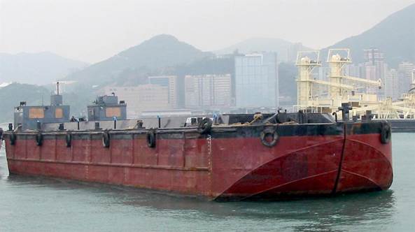
APPENDIX E Photos of Working Vessels |
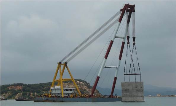
Crane barge
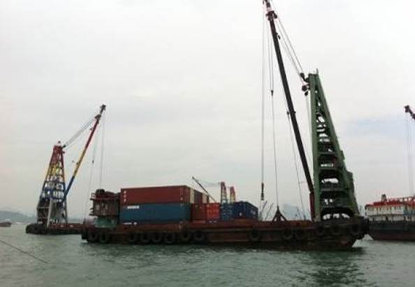
Derrick Lighter
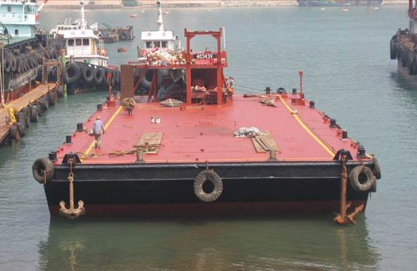
Flat Top Barge
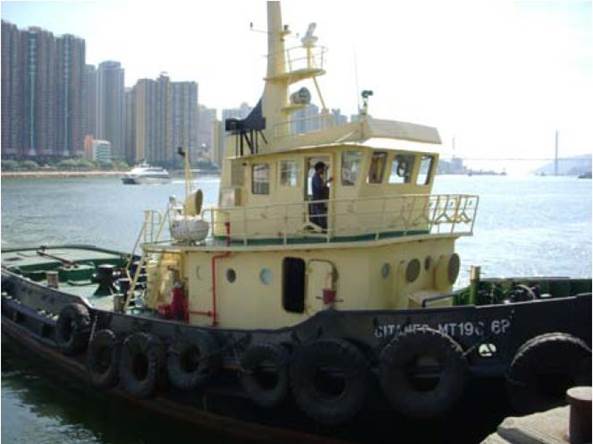
Tug Boat
Hopper Barge
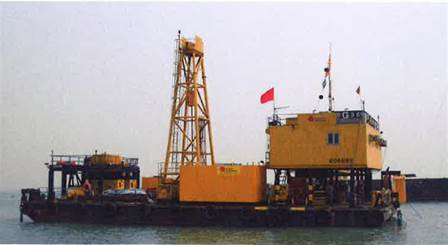
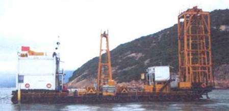
Marine G.I. Vessel
Inspection boat (e.g.
Passenger ferry/ Sampan)
|
Crane
Barge |
|
||||||||||||
|
Item |
Type
of Marine Vessel |
Owner |
Lifting
Capacity (ton) |
Lifting
height (m) |
Outreach
(m) |
Sea-draft
under full load (m) |
Length
(m) |
Breath
(m) |
|||||
|
1 |
�a�u8-Guan Gon 8 |
FB |
500 |
47.4 |
18.4 |
2.8 |
61.2 |
21.3 |
|||||
|
Derrick Lighter |
|
||||||||||||
|
Item |
Type
of Marine Vessel |
Owner |
Lifting
Capacity (ton) |
Carrying Capacity
(ton) |
Outreach
&lifting height(m) |
Sea-draft
under full load (m) |
Length (m) |
Breath (m) |
|||||
|
2 |
�w��-Tak Kee |
Yun Lee |
45t |
2,400 |
20 |
4.36 |
47 |
20 |
|||||
|
Flat Top Barge |
|
||||||||||||
|
Item |
Type
of Marine Vessel |
Owner |
Carrying Capacity
(ton) |
Length (m) |
Breath (m) |
||||||||
|
3 |
Humber River |
Tung Shun |
1,800 |
47.73 |
15.24 |
||||||||
|
Tug Boat |
|
||||||||||||
|
Item |
Type
of Marine Vessel |
Owner |
Horse
Power (Bhp) |
Length (m) |
Breath (m) |
||||||||
|
4 |
1280hp Tugboat |
UDL |
1,280 |
23.4 |
7.2 |
||||||||
|
Hopper Barge |
|
||||||||||||
|
Item |
Type
of Marine Vessel |
Owner |
Volume
(m³) |
Net
Reg. Tonnage |
Depth
(m) |
Draft
(m) |
Length
(m) |
Breadth
(m) |
|||||
|
5 |
1000cu.m
Spilt Hopper Barge |
UDL |
1,000 |
764.1 |
4.7 |
4.04 |
49.91 |
12.4 |
|||||
|
Marine G.I. Vessel |
|
||||||||||||
|
Item |
Type
of Marine Vessel |
Owner |
Length
(m) |
Breath
(m) |
|||||||||
|
6 |
Flat
top barge |
Gammon |
25 or
32.5 |
12 |
|||||||||
Table 1 �V General Information of Working Vessels
|
APPENDIX F Marine Routes and Frequency between the Works Areas |
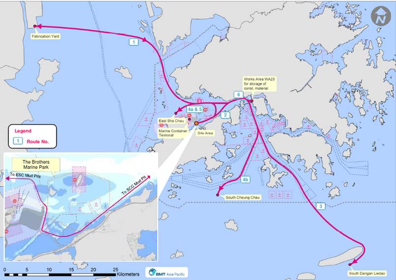
Figure 1 - Regular Marine Travel Routes of Working Vessels
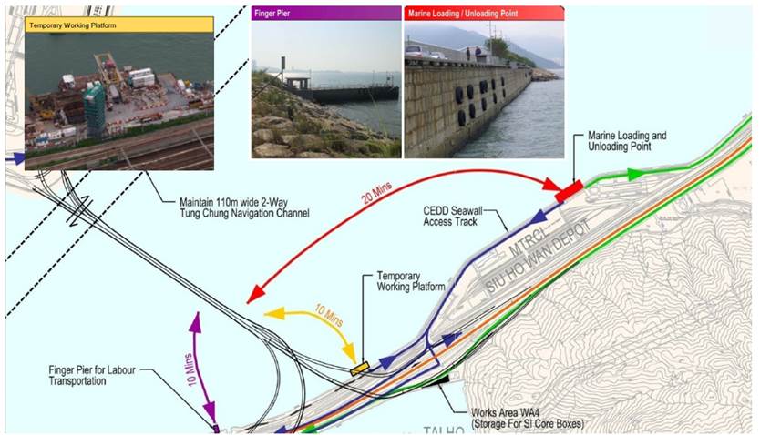
Figure 2 - Inspection Boat Travel Routes and Local Land-to-Sea Delivery Routes (Route No. 7)
|
RouteNo. |
Regular
Travel Routes |
Purpose |
Vessels Particulars |
Period |
Anticipated
Frequency of Travel (round trip) |
|
1 |
Fabrication
Yard ↔ Site Area |
Delivery
of precast & pre-fabricated units |
1)
Flat top barge 2)
Tug boat |
30 Jun 2014 �V TBA |
4 times/day |
|
2 |
Works
Area WA23 ↔Site Area |
Delivery
of precast & pre-fabricated units and piling materials |
1)
Derrick lighter 2)
Crane barge 3)
Flat top barge 4)
Tug boat |
1 Mar 2014 �V TBA |
4 times/week |
|
3 |
Site
Area ↔ South of Dangan
Liedao |
Disposal
of Cat. L & Mp marine deposits |
1)
Hopper barge 2)
Tug boat |
Subject to instruction from SOR |
As-need basis |
|
4a |
Site
Area ↔ East Sha Chau exhausted CMP |
Disposal
of Cat. L marine deposits |
1) Hopper barge 2)
Tug
boat |
1 Mar 2014 �V 31 Dec 2017 |
2 times/month |
|
4b |
Site
Area ↔ South Cheung Chau |
||||
|
5 |
Site
Area ↔ East Sha Chau CMP |
Disposal
of Cat. Mp, Mf & H marine deposits |
1)
Hopper
barge 2)
Tug
boat |
1 Mar 2014 �V 31 Dec 2017 |
2 times/month |
|
6 |
Fabrication
Yard ↔ WA23 |
Delivery
of precast & pre-fabricated units for storage |
1)
Flat top barge 2)
Tug boat |
30 Jun 2014 �V TBA |
1 time/week |
|
7 |
Site Area ↔ boarding jetties along |
Workers/ project staff
transportation |
1)
Inspection boats |
Throughout the Contract period |
As-need basis |
Table 2 �V Information of Regular Travel Routes
Annex 1 - Emergency
Marine Routes for Working Vessel to the Typhoon Shelter during Adverse Weather